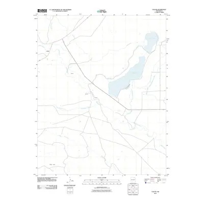
2010 Map of Colfax
USGS Topo · Published 2010About this map
Colfax serves as the focal point of this northern New Mexico landscape, situated at a junction of roads and waterways during the first decade of the 21st century. The map illustrates a complex network of water management, centered on the Stubblefield Reservoir and supported by infrastructure like the High Line Ditch, Rito Presa, and the Stubblefield Lateral. These features suggest a landscape deeply tied to irrigation and livestock, where the Vermejo River and Van Bremmer Creek provide the primary natural drainage across the plains. Small rural settlements and family-named locales such as Messick, Pompoe, and Martinez are scattered south of the main town, connected by County Road A-61. The southern portion of the quadrangle transitions into the Cedar Hills, where the land is carved by the Dry Arroyo, reflecting the high-desert character of the region near Laguna Madre.
Find a feature on this map
19 named features on this map. Tap any name to fly to it.
Don’t see what you’re looking for? This feature index may not catch every label — zoom into the map to look around manually.
Map Details
Editions of this 2010 Colfax Map
This is the sole edition of this map. No revisions or reprints were ever made.
Other maps of this area

1915 · Koehler
USGS Topo · 1:62,500

1917 · Koehler
USGS Topo · 1:62,500

1954 · Raton
USGS Topo · 1:250,000

1955 · Cimarron
USGS Topo · 1:62,500

1956 · Miami
USGS Topo · 1:62,500

1958 · Raton
USGS Topo · 1:250,000

1965 · French
USGS Topo · 1:24,000

1965 · Springer Lake
USGS Topo · 1:24,000

1971 · Saltpeter Mountain
USGS Topo · 1:24,000
1971 · Colfax
USGS Topo · 1:24,000