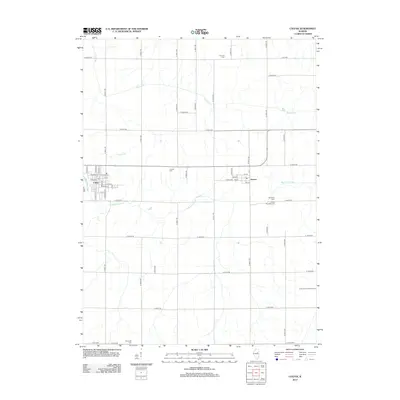
2012 Map of Colfax
USGS Topo · Published 2012About this map
The Mackinaw River winds through this central Illinois landscape, defining the agricultural character of McLean County. The village of Colfax sits at the western edge of the quadrangle, with its residential grid organized around W Main St and the local Po. To the east, the smaller settlement of Anchor occupies a crossroads near the river, surrounded by a high density of rural burial grounds that speak to the area's long-standing family farming heritage. These include Antioch Cem, Township Cem, and Anchor Township Cem. The drainage patterns of Henline Cr and Colfax Cr break the geometric regularity of the section-line roads, such as E 2100 N RD, which connect these small communities across the productive prairie.
Find a feature on this map
56 named features on this map. Tap any name to fly to it.
Don’t see what you’re looking for? This feature index may not catch every label — zoom into the map to look around manually.
Map Details
Editions of this 2012 Colfax Map
This is the sole edition of this map. No revisions or reprints were ever made.
Other maps of this area

1928 · Gibson City
USGS Topo · 1:62,500

1947 · Sibley
USGS Topo · 1:62,500

1949 · Sibley
USGS Topo · 1:62,500

1952 · Arrowsmith
USGS Topo · 1:62,500

1957 · Gibson City
USGS Topo · 1:62,500

1957 · Colfax
USGS Topo · 1:62,500

1958 · Peoria
USGS Topo · 1:250,000

1961 · Peoria
USGS Topo · 1:250,000

1963 · Peoria
USGS Topo · 1:250,000
1982 · Gibson City West
USGS Topo · 1:24,000