
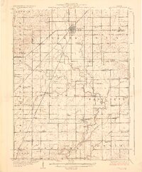
1928 Map of Gibson City
USGS Topo · Published 1928About this map
Gibson City serves as the primary rail hub on this Central Illinois landscape, where the Illinois Central RR, Wabash RR, and New York Chicago and St Louis RR all converge. The map illustrates a highly organized agricultural grid dotted with an extraordinary number of rural schoolhouses, such as Scotland School, Victoria School, and Caledonia School, indicating a dense population of farming families during the mid-1920s. The meandering course of the Sangamon River and its tributaries like Drummer Creek and Lone Tree Creek provide the only break in the rectilinear township surveys. Smaller villages like Fisher and Elliott are clearly defined by their relationship to the rail lines, while numerous named schools such as Prairie Cottage School and Wildrose School mark the vanished educational centers of these rural communities.
Find a feature on this map
81 named features on this map. Tap any name to fly to it.
Don’t see what you’re looking for? This feature index may not catch every label — zoom into the map to look around manually.
Map Details
Editions of this 1928 Gibson City Map
2 editions found
Other maps of this area

1906 · Urbana
USGS Topo · 1:62,500

1907 · Mahomet
USGS Topo · 1:62,500

1924 · Paxton
USGS Topo · 1:62,500

1927 · Paxton
USGS Topo · 1:62,500

1937 · Monticello
USGS Topo · 1:48,000

1943 · Monticello
USGS Topo · 1:62,500

1947 · Sibley
USGS Topo · 1:62,500

1948 · Buckley
USGS Topo · 1:62,500

1949 · Buckley
USGS Topo · 1:62,500

1949 · Paxton
USGS Topo · 1:62,500