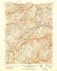
1938 Map of Colfax
USGS Topo · Published 1950About this map
Gold-rush era settlements and deep river canyons dominate this landscape surveyed in 1932. The terrain is defined by the steep drainage basins of the North Fork American River, Middle Fork American River, and multiple branches of the Yuba River. Along the ridges, historic mining towns like Alleghany, North Bloomfield, and Dutch Flat are connected by early automotive routes including the Lincoln Highway and Victory Highway. The Southern Pacific RR carves a dramatic path through the mountains, notably passing through Colfax and around the steep grade at Cape Horn.
Find a feature on this map
80 named features on this map. Tap any name to fly to it.
Don’t see what you’re looking for? This feature index may not catch every label — zoom into the map to look around manually.
Map Details
Editions of this 1938 Colfax Map
3 editions found

Other maps of this area

1888 · Smartsville
USGS Topo · 1:125,000

1888 · Bidwell Bar
USGS Topo · 1:125,000

1889 · Pyramid Peak
USGS Topo · 1:125,000

1890 · Sierraville
USGS Topo · 1:125,000

1891 · Bidwell Bar
USGS Topo · 1:125,000

1891 · Downieville
USGS Topo · 1:125,000

1891 · Sacramento
USGS Topo · 1:125,000

1891 · Colfax
USGS Topo · 1:125,000

1891 · Truckee
USGS Topo · 1:125,000

1891 · Smartsville
USGS Topo · 1:125,000