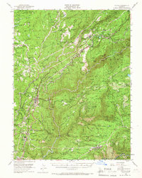
1950 Map of Colfax
USGS Topo · Published 1966About this map
Colfax serves as the central hub of this mid-century survey, situated where the Southern Pacific tracks wind through the foothills of the Sierra Nevada. The landscape is a complex network of industrial history and small settlements, heavily defined by the gold-mining legacy of Placer and Nevada Counties. Deep canyons carved by the North Fork American River and the Bear River create dramatic verticality, separating ridge-top communities like Dutch Flat and Alta from the hydraulic diggings and mines below. The map documents an era of transition, showing the Sanatorium at Weimar and the persistent infrastructure of the gold rush, including the Iowa Hill Mine and Banner Mine. Small homesteads and family-named landmarks like John Brown Flat and Brady Ranch are scattered across the Tahoe National Forest, offering a detailed look at the rural habitation patterns before modern expansion.
Find a feature on this map
204 named features on this map. Tap any name to fly to it.
Don’t see what you’re looking for? This feature index may not catch every label — zoom into the map to look around manually.
Map Details
Editions of this 1950 Colfax Map
4 editions found
Other maps of this area

1888 · Smartsville
USGS Topo · 1:125,000

1891 · Sacramento
USGS Topo · 1:125,000

1891 · Colfax
USGS Topo · 1:125,000

1891 · Smartsville
USGS Topo · 1:125,000

1891 · Placerville
USGS Topo · 1:125,000

1892 · Sacramento
USGS Topo · 1:125,000

1892 · Placerville
USGS Topo · 1:125,000

1892 · Smartsville
USGS Topo · 1:125,000

1892 · Colfax
USGS Topo · 1:125,000

1893 · Placerville
USGS Topo · 1:125,000