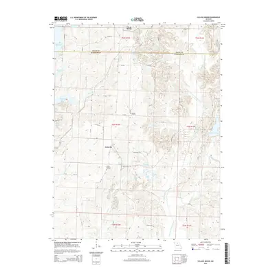
2014 Map of College Mound
USGS Topo · Published 2014About this map
The E Fork Little Chariton River and the sprawling western banks of the Thomas Hill Reservoir define this portion of north-central Missouri. In the early 21st century, the landscape remains a mix of agricultural plots and managed water bodies, including several named private impoundments such as Solitude Lake, Adams Lake, and Thomas Brothers Lake. Local history is anchored by the small settlements of College Mound and Darksville, which reflect the area's rural character and long-standing community centers. Family and local heritage can be traced through sites like Hickory Grove Cemetery and Barnhart Cemetery, which are situated among the network of county roads such as Co Road B12 and CR-1170. The topography is marked by numerous drainages, including Dark Cr, Muncas Cr, and Brush Cr, which feed into the larger river and reservoir systems that dominate the region's hydrology.
Find a feature on this map
63 named features on this map. Tap any name to fly to it.
Don’t see what you’re looking for? This feature index may not catch every label — zoom into the map to look around manually.
Map Details
Editions of this 2014 College Mound Map
This is the sole edition of this map. No revisions or reprints were ever made.
Other maps of this area

1890 · Moberly
USGS Topo · 1:125,000

1890 · Glasgow
USGS Topo · 1:125,000

1908 · Macon
USGS Topo · 1:62,500

1910 · Macon
USGS Topo · 1:62,500

1953 · Moberly
USGS Topo · 1:250,000

1953 · Huntsville
USGS Topo · 1:24,000

1953 · Bevier South
USGS Topo · 1:24,000

1953 · College Mound
USGS Topo · 1:24,000

1953 · Clifton Hill
USGS Topo · 1:24,000
1953 · Moberly
USGS Topo · 1:24,000