
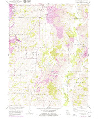
1953 Map of College Mound
USGS Topo · Published 1955About this map
College Mound and Darksville anchor this rural landscape in north-central Missouri, where the rolling hills of the Macon and Randolph County line meet a heavy industrial footprint. The landscape is defined by the extensive operations of a strip mine, which has reshaped the terrain between the East Fork Chariton River and the Bevier and Southern railroad. This industrial activity contrasts with the traditional rural network of schools and churches, several of which were already marked as inactive during this mid-century period, such as Crisman Sch and Hickory Sch. Genealogists will find significant detail in the placement of rural burial grounds like Barnhart Cem and Hickory Grove Cem, alongside active country congregations at Union Chapel and Mt Pleasant Ch. The drainage patterns of Brush Creek, Dark Creek, and Muncas Creek show how the topography dictated the early settlement patterns of the Chariton valley.
Find a feature on this map
30 named features on this map. Tap any name to fly to it.
Don’t see what you’re looking for? This feature index may not catch every label — zoom into the map to look around manually.
Map Details
Editions of this 1953 College Mound Map
2 editions found
Other maps of this area

1890 · Moberly
USGS Topo · 1:125,000

1890 · Glasgow
USGS Topo · 1:125,000

1908 · Macon
USGS Topo · 1:62,500

1910 · Macon
USGS Topo · 1:62,500

1953 · Moberly
USGS Topo · 1:250,000

1953 · Huntsville
USGS Topo · 1:24,000

1953 · Bevier South
USGS Topo · 1:24,000

1953 · Clifton Hill
USGS Topo · 1:24,000
1953 · Moberly
USGS Topo · 1:24,000

1953 · Prairie Hill
USGS Topo · 1:24,000