
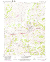
1953 Map of Huntsville
USGS Topo · Published 1955About this map
Huntsville serves as the focal point of this mid-century Randolph County survey, situated along the Wabash railroad line. The landscape is heavily marked by the region's industrial activity, featuring numerous Strip Mine operations north of the city and the Hannah Mine to the southeast. Outside the central settlement, the map reveals a network of small rural communities and civic foundations, including the scattered locations of Lincoln Sch, Benton Sch, and Wright Sch.
Find a feature on this map
35 named features on this map. Tap any name to fly to it.
Don’t see what you’re looking for? This feature index may not catch every label — zoom into the map to look around manually.
Map Details
Editions of this 1953 Huntsville Map
2 editions found
Other maps of this area

1890 · Moberly
USGS Topo · 1:125,000

1890 · Glasgow
USGS Topo · 1:125,000

1908 · Macon
USGS Topo · 1:62,500

1910 · Macon
USGS Topo · 1:62,500

1953 · Moberly
USGS Topo · 1:250,000

1953 · Renick
USGS Topo · 1:24,000

1953 · Higbee
USGS Topo · 1:24,000

1953 · College Mound
USGS Topo · 1:24,000

1953 · Armstrong
USGS Topo · 1:24,000

1953 · Clifton Hill
USGS Topo · 1:24,000