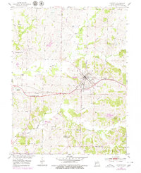
1953 Map of Huntsville
USGS Topo · Published 1979About this map
The city of Huntsville serves as the central hub of this mid-Missouri landscape, situated at the junction of the Wabash railroad and the rolling terrain of Salt Spring township. The map reveals an area defined by its natural watercourses, with the Chariton River and Little Chariton River flowing through a countryside dotted with rural institutions. Education and faith were clearly central to the community's fabric, as evidenced by a dense network of local schools and churches such as Lincoln Sch, Oliver Sch, and Mt Salem Ch Providence Ch. Local industry is represented by several active extractive sites, including the Hannah Mine and numerous Strip Mine operations scattered throughout the northern and eastern sections. Small settlements and historical locales like Randolph Springs and Fort Henry further illustrate the early settlement patterns of Randolph County during this era of post-war growth and industrial transition.
Find a feature on this map
39 named features on this map. Tap any name to fly to it.
Don’t see what you’re looking for? This feature index may not catch every label — zoom into the map to look around manually.
Map Details
Editions of this 1953 Huntsville Map
2 editions found
Other maps of this area

1890 · Moberly
USGS Topo · 1:125,000

1890 · Glasgow
USGS Topo · 1:125,000

1908 · Macon
USGS Topo · 1:62,500

1910 · Macon
USGS Topo · 1:62,500

1953 · Moberly
USGS Topo · 1:250,000

1953 · Renick
USGS Topo · 1:24,000

1953 · Huntsville
USGS Topo · 1:24,000

1953 · Higbee
USGS Topo · 1:24,000

1953 · College Mound
USGS Topo · 1:24,000

1953 · Armstrong
USGS Topo · 1:24,000