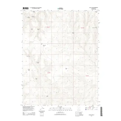
2014 Map of Collet Top
USGS Topo · Published 2014About this map
Collet Top stands as a prominent high point within the sprawling landscape of the Kaiparowits Plateau in Kane County. This 2014 survey by the U.S. Geological Survey details a labyrinth of drainage systems including Left Hand Collet Canyon, Cigar Creek Canyon, and Button Canyon. The terrain is defined by dramatic elevation changes between Window Sash Bench and the towering Straight Cliffs to the northeast. Human presence is sparse, marked primarily by the unimproved path of Missing Canyon Rd, while isolated water sources like Circle Spring highlight the arid nature of this remote section of Southern Utah. Geologists and topographical enthusiasts can trace the complex network of gulches and canyons, such as Willow Gulch and Steer Canyon, which illustrate the heavy erosion patterns characteristic of the region.
Find a feature on this map
20 named features on this map. Tap any name to fly to it.
Don’t see what you’re looking for? This feature index may not catch every label — zoom into the map to look around manually.
Map Details
Editions of this 2014 Collet Top Map
This is the sole edition of this map. No revisions or reprints were ever made.
Other maps of this area

1886 · Escalante
USGS Topo · 1:250,000

1922 · Upper Last Chance
USGS Topo · 1:63,360

1922 · Rees Canyon
USGS Topo · 1:63,360

1956 · Escalante
USGS Topo · 1:250,000

1960 · Escalante
USGS Topo · 1:250,000

1964 · Sunset Flat
USGS Topo · 1:24,000

1964 · Seep Flat
USGS Topo · 1:24,000

1964 · Carcass Canyon
USGS Topo · 1:24,000

1968 · East of The Navajo
USGS Topo · 1:24,000
1968 · Petes Cove
USGS Topo · 1:24,000