
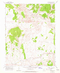
1964 Map of Seep Flat
USGS Topo · Published 1966About this map
Seep Flat and the towering Straight Cliffs dominate this mid-1960s topographic study of the high desert along the border of Garfield and Kane counties. The landscape is defined by the dramatic incision of Right Hand Collet Canyon and Left Hand Collet Canyon, which cut through the uplifted plateaus toward the southeastern drainage of Twentymile Wash. This survey captures the region when its primary human infrastructure consisted of remote livestock facilities like Twentymile Corral and isolated water sources such as Barney Reservoir and Slickrock Water. The mapping of a singular Jeep Trail winding through the terrain suggests the limited accessibility of the era, while the inclusion of the Devils Garden highlights the area's unusual geological formations and erosion patterns.
Find a feature on this map
12 named features on this map. Tap any name to fly to it.
Don’t see what you’re looking for? This feature index may not catch every label — zoom into the map to look around manually.
Map Details
Editions of this 1964 Seep Flat Map
2 editions found

Other maps of this area

1886 · Escalante
USGS Topo · 1:250,000

1922 · Upper Last Chance
USGS Topo · 1:63,360

1922 · Rees Canyon
USGS Topo · 1:63,360

1956 · Escalante
USGS Topo · 1:250,000

1960 · Escalante
USGS Topo · 1:250,000

1964 · Sunset Flat
USGS Topo · 1:24,000

1964 · Tenmile Flat
USGS Topo · 1:24,000

1964 · Dave Canyon
USGS Topo · 1:24,000

1964 · Carcass Canyon
USGS Topo · 1:24,000
1964 · Red Breaks
USGS Topo · 1:24,000