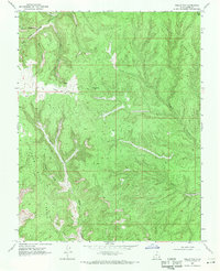
1968 Map of Collet Top
USGS Topo · Published 1971About this map
Fiftymile Mountain and the Straight Cliffs dominate this 1968 landscape, where high plateaus meet a complex network of drainage systems. The presence of a Landing Strip and an Oil Well on the flat expanse of Collet Top indicates the industrial and logistical reach into this remote canyon country during the late 1960s. The topography is defined by deep incisions from Horse Canyon, Reese Canyon, and Collet Canyon, creating the prominent Window Sash Bench. Numerous primitive routes, including a Jeep Trail, connect reliable water sources like Circle Spring with the lower elevations of Willow Gulch. These details provide a look at land use in Kane County before the era of modern road development and wilderness designations.
Find a feature on this map
19 named features on this map. Tap any name to fly to it.
Don’t see what you’re looking for? This feature index may not catch every label — zoom into the map to look around manually.
Map Details
Editions of this 1968 Collet Top Map
This is the sole edition of this map. No revisions or reprints were ever made.
Other maps of this area

1886 · Escalante
USGS Topo · 1:250,000

1922 · Upper Last Chance
USGS Topo · 1:63,360

1922 · Rees Canyon
USGS Topo · 1:63,360

1956 · Escalante
USGS Topo · 1:250,000

1960 · Escalante
USGS Topo · 1:250,000

1964 · Sunset Flat
USGS Topo · 1:24,000

1964 · Seep Flat
USGS Topo · 1:24,000

1964 · Carcass Canyon
USGS Topo · 1:24,000

1968 · East of The Navajo
USGS Topo · 1:24,000
1968 · Petes Cove
USGS Topo · 1:24,000