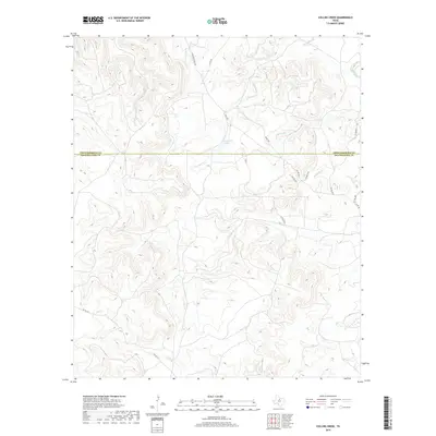
2019 Map of Collins Creek
USGS Topo · Published 2019About this map
Lambshead Cr and its various tributaries define the drainage of this north-central Texas landscape, which straddles the boundary between Throckmorton and Shackelford counties. This area is characterized by vast private ranch holdings, evidenced by the presence of Matthews Ranch Rd and a network of named private and county routes like Watt Rd and Co Rd 292. The geography is centered on the water management essential for livestock in this region, including Lambshead Tank and the larger Clear Fork in the northeast corner. While largely uninhabited by dense settlements, the map documents the intricate network of ranch roads and small drainage features such as Jackson Br, Reynolds Br, and Walnut Cr that have supported the local cattle industry for generations.
Find a feature on this map
20 named features on this map. Tap any name to fly to it.
Don’t see what you’re looking for? This feature index may not catch every label — zoom into the map to look around manually.
Map Details
Editions of this 2019 Collins Creek Map
This is the sole edition of this map. No revisions or reprints were ever made.
Other maps of this area

1892 · Albany
USGS Topo · 1:125,000

1893 · Albany
USGS Topo · 1:125,000

1954 · Abilene
USGS Topo · 1:250,000

1954 · Wichita Falls
USGS Topo · 1:250,000

1958 · Wichita Falls
USGS Topo · 1:250,000

1958 · Abilene
USGS Topo · 1:250,000

1965 · Collins Creek
USGS Topo · 1:24,000
1965 · Collins Creek SW
USGS Topo · 1:24,000
1965 · Antelope Hills
USGS Topo · 1:24,000

1965 · Fort Griffin
USGS Topo · 1:24,000