
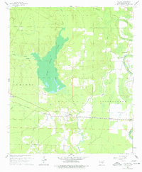
1960 Map of Collins
USGS Topo · Published 1961About this map
Bayou Bartholomew and its winding tributaries dominate this 1960 landscape in Drew County, where the delta terrain transitions into complex wetlands and wooded bottoms. The settlement of Collins serves as a local hub along the Missouri Pacific railroad, which cuts east-west across the southern portion of the quadrangle. The presence of Seven Devils Lake and Big Lake indicates a low-lying, water-dense environment shaped by the natural meanders of Cutoff Creek and the Collins Cutoff Creek. Genealogy interests are well-served by the inclusion of several small community landmarks, including Little Zion Ch, Gethsemane Ch, and the Solomon Allen Cem. This survey captures the rural character of southeastern Arkansas before major modern agricultural shifts, documenting the precise locations of family cemeteries like Mt Olive Cem and Bowden Cem that often mark the sites of early homesteads.
Find a feature on this map
22 named features on this map. Tap any name to fly to it.
Don’t see what you’re looking for? This feature index may not catch every label — zoom into the map to look around manually.
Map Details
Editions of this 1960 Collins Map
2 editions found
Other maps of this area

1935 · Mist
USGS Topo · 1:62,500

1935 · Cominto
USGS Topo · 1:62,500

1936 · McGehee
USGS Topo · 1:62,500

1936 · Lake Village
USGS Topo · 1:62,500

1937 · McGehee
USGS Topo · 1:62,500

1953 · Greenwood
USGS Topo · 1:250,000

1955 · Lake Village
USGS Topo · 1:62,500

1955 · McGehee
USGS Topo · 1:62,500

1956 · Greenwood
USGS Topo · 1:250,000

1960 · Mist
USGS Topo · 1:62,500