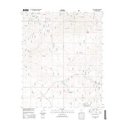
2013 Map of Collins Park
USGS Topo · Published 2013About this map
The Continental Divide crests through this high-altitude landscape in the Gila National Forest, defining a region where water management was historically critical for ranching and forest operations. Collins Park serves as a central landmark in this southwestern Catron County terrain, surrounded by a complex network of artificial water sources like Collins Park Tank, Spurgeon Tank, and Salt Lick Tank. The land is deeply incised by numerous drainages, including the drainage systems of Bear Canyon and Wine Canyon, which fall away from the heights of the Long Canyon Mountains. Local infrastructure is defined by remote corridors such as Bursum Rd and Forest Rd 94, which provide access to isolated springs like Five Springs and Davis Spring. This survey reveals the specialized nomenclature of a working forest landscape, where natural features like Ghost Lake and Pinon Knob exist alongside carefully placed stock tanks and canyon systems.
Find a feature on this map
48 named features on this map. Tap any name to fly to it.
Don’t see what you’re looking for? This feature index may not catch every label — zoom into the map to look around manually.
Map Details
Editions of this 2013 Collins Park Map
This is the sole edition of this map. No revisions or reprints were ever made.
Other maps of this area

1915 · Reserve
USGS Topo · 1:125,000

1918 · Pelona
USGS Topo · 1:125,000

1918 · Reserve
USGS Topo · 1:125,000

1954 · Clifton
USGS Topo · 1:250,000

1957 · Clifton
USGS Topo · 1:250,000

1958 · Clifton
USGS Topo · 1:250,000

1962 · Clifton
USGS Topo · 1:250,000
1963 · Pitchfork Canyon
USGS Topo · 1:24,000
1963 · Telephone Canyon
USGS Topo · 1:24,000
1965 · Eagle Peak
USGS Topo · 1:24,000