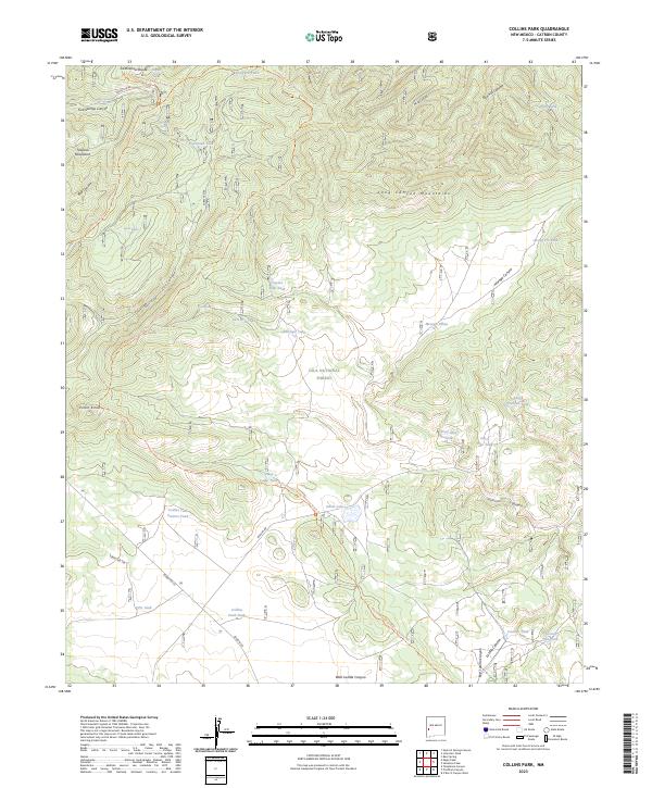
2023 Map of Collins Park
USGS Topo · Published 2023About this map
The Continental Divide National Scenic Trl snakes across this high-altitude landscape in Catron County, following the Continental Divide through the heart of the Gila National Forest. This terrain is defined by the convergence of the Tularosa Mountains and the Long Canyon Mountains, where a complex network of canyons like Cox Canyon and Bear Canyon drain the wooded uplands. The distribution of water sources is the primary indicator of land use in this part of New Mexico, with numerous named tanks and springs supporting seasonal livestock or wildlife. Notable landmarks such as Pinon Knob and Ghost Lake punctuate the forest, while remote tracks like Bursum Rd and Forest Rd 94 provide the only significant access through these peaks. Researchers will find a concentrated cluster of features around Collins Park Tank and Collins Park Pasture Tank, reflecting the local importance of these water points in a high-desert environment.
Find a feature on this map
48 named features on this map. Tap any name to fly to it.
Don’t see what you’re looking for? This feature index may not catch every label — zoom into the map to look around manually.
Map Details
Editions of this 2023 Collins Park Map
This is the sole edition of this map. No revisions or reprints were ever made.
Other maps of this area

1915 · Reserve
USGS Topo · 1:125,000

1918 · Pelona
USGS Topo · 1:125,000

1918 · Reserve
USGS Topo · 1:125,000

1954 · Clifton
USGS Topo · 1:250,000

1957 · Clifton
USGS Topo · 1:250,000

1958 · Clifton
USGS Topo · 1:250,000

1962 · Clifton
USGS Topo · 1:250,000
1963 · Pitchfork Canyon
USGS Topo · 1:24,000
1963 · Telephone Canyon
USGS Topo · 1:24,000
1965 · Eagle Peak
USGS Topo · 1:24,000