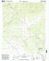
1999 Map of Collins Parks
USGS Topo · Published 2002About this map
The Continental Divide crests through this high-altitude landscape of the Gila National Forest, dictating the flow of water across a series of deep canyons and peaks. During the late twentieth century, the area served primarily as a pastoral and recreation zone, evidenced by the numerous water improvements like Collins Park Tank and Collins Park Well that supported livestock in this arid environment. The Continental Divide National Scenic Trail traverses the ridges, crossing through the Tularosa Mountains and passing notable landmarks such as Piñon Knob. Below the heights, the Bursum Road provides the primary transit through the region, following the drainage of the North Fork Negrito Creek. The map documents a rugged network of specialized tanks and springs, including Dutchman Spring and Ghost Lake, which were essential for ranching and forest management in this corner of New Mexico.
Find a feature on this map
43 named features on this map. Tap any name to fly to it.
Don’t see what you’re looking for? This feature index may not catch every label — zoom into the map to look around manually.
Map Details
Editions of this 1999 Collins Parks Map
This is the sole edition of this map. No revisions or reprints were ever made.
Other maps of this area

1915 · Reserve
USGS Topo · 1:125,000

1918 · Pelona
USGS Topo · 1:125,000

1918 · Reserve
USGS Topo · 1:125,000

1954 · Clifton
USGS Topo · 1:250,000

1957 · Clifton
USGS Topo · 1:250,000

1958 · Clifton
USGS Topo · 1:250,000

1962 · Clifton
USGS Topo · 1:250,000
1963 · Pitchfork Canyon
USGS Topo · 1:24,000
1963 · Telephone Canyon
USGS Topo · 1:24,000
1965 · Eagle Peak
USGS Topo · 1:24,000