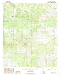
1987 Map of Collirene
USGS Topo · Published 1987About this map
Collirene serves as a central landmark in this 1980s landscape, situated where the terrain begins to ripple between drainage basins. The area is defined by a dense network of seasonal and perennial waterways, including Mush Creek and Soapstone Creek, which carve through the elevations of Mt Baber and Hicks Hill. Historical settlement patterns are visible at Old Town and Halls, often located near these vital water sources or on the high ground overlooking the creek bottoms. Small-scale industrial activity is evidenced by Clay Pits and a Clay Pit located in the rural sections, suggesting local resource extraction during this era. The map also documents several Cem sites, providing valuable data points for those researching family history or the early development of the rural infrastructure along the Dallas and Lowndes County line.
Find a feature on this map
17 named features on this map. Tap any name to fly to it.
Don’t see what you’re looking for? This feature index may not catch every label — zoom into the map to look around manually.
Map Details
Editions of this 1987 Collirene Map
This is the sole edition of this map. No revisions or reprints were ever made.
Other maps of this area

1953 · Montgomery
USGS Topo · 1:250,000

1956 · Montgomery
USGS Topo · 1:250,000

1957 · Montgomery
USGS Topo · 1:250,000

1957 · Autaugaville
USGS Topo · 1:62,500

1957 · Benton
USGS Topo · 1:62,500

1957 · Braggs
USGS Topo · 1:62,500

1975 · Benton SE
USGS Topo · 1:24,000

1975 · Autaugaville SW
USGS Topo · 1:24,000
1975 · Benton SW
USGS Topo · 1:24,000
1981 · Gordonsville
USGS Topo · 1:24,000