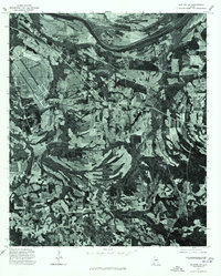
1975 Map of Benton SW
USGS Topo · Published 1977About this map
The Alabama River sweeps across the northern boundary of this 1975 orthophotoquad, defining a landscape of deep alluvial bends and dense river-bottom timber. This specialized aerial imagery provides a direct look at the mid-1970s agricultural patterns in Dallas County, where large cultivated fields are carved out of the forested terrain. The small community of Sardis is situated in the western portion of the map, while Tyler anchors the eastern side. The imagery reveals the stark layout of a significant airfield and its associated infrastructure, showing the intersection of rural southern life with mid-century transportation and aviation developments. Unlike traditional topographic maps, this aerial perspective captures the exact footprint of farmsteads and the fine-grained texture of the Alabama riverfront as it appeared in the mid-1970s.
Find a feature on this map
3 named features on this map. Tap any name to fly to it.
Don’t see what you’re looking for? This feature index may not catch every label — zoom into the map to look around manually.
Map Details
Editions of this 1975 Benton SW Map
This is the sole edition of this map. No revisions or reprints were ever made.
Other maps of this area

1953 · Montgomery
USGS Topo · 1:250,000

1956 · Montgomery
USGS Topo · 1:250,000

1957 · Montgomery
USGS Topo · 1:250,000

1957 · Carlowville
USGS Topo · 1:62,500

1957 · Benton
USGS Topo · 1:62,500

1957 · Braggs
USGS Topo · 1:62,500

1958 · Selma
USGS Topo · 1:62,500

1958 · Selma
USGS Topo · 1:24,000

1975 · Benton SE
USGS Topo · 1:24,000

1975 · Selma SE
USGS Topo · 1:24,000