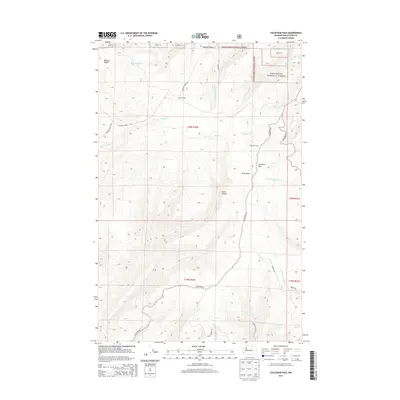
2014 Map of Colockum Pass
USGS Topo · Published 2014About this map
Colockum Pass serves as the central focal point of this high-altitude landscape in Kittitas County, where the eastern slopes of the Cascades transition into the drainage basins of the Columbia River. The map detail highlights a network of forest roads and pack routes, such as Colockum Rd and Jumpoff Ridge Rd, which provide access to the remote Wenatchee National Forest. Scattered locations like Mountain Home and Four Corners suggest seasonal or specialized use of the ridgelines. Deep topographical incisions such as Cooke Canyon and Stray Gulch define the rugged character of the area. A complex system of headwaters, including Coleman Cr, Tarpiscan Cr, and Caribou Cr, flows from the heights of Naneum Ridge and Jumpoff Ridge, illustrating the vital role this terrain plays in the region's watershed.
Find a feature on this map
34 named features on this map. Tap any name to fly to it.
Don’t see what you’re looking for? This feature index may not catch every label — zoom into the map to look around manually.
Map Details
Editions of this 2014 Colockum Pass Map
This is the sole edition of this map. No revisions or reprints were ever made.
Other maps of this area

1912 · Malaga
USGS Topo · 1:48,000

1913 · Wenatchee
USGS Topo · 1:62,500

1914 · Malaga
USGS Topo · 1:62,500

1915 · Wenatchee
USGS Topo · 1:62,500

1920 · Colockum Pass
USGS Topo · 1:125,000

1922 · Colockum Pass
USGS Topo · 1:125,000

1957 · Wenatchee
USGS Topo · 1:250,000
1966 · Colockum Pass SW
USGS Topo · 1:24,000
1966 · Colockum Pass SE
USGS Topo · 1:24,000
1966 · Colockum Pass
USGS Topo · 1:24,000