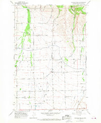
1966 Map of Colockum Pass SW
USGS Topo · Published 1967About this map
Kittitas Valley agriculture and ranching infrastructure define this mid-1960s landscape, where a dense network of irrigation and transport supports scattered rural settlements. The map illustrates the transition from the high canyons of the north, including Cave Canyon and Burnt Canyon, to the organized section lines of the valley floor. Water management is central to the area's development, evidenced by the Pyle Canal and Canal No 2 alongside the natural flows of Naneum Creek and Wilson Creek.
Find a feature on this map
41 named features on this map. Tap any name to fly to it.
Don’t see what you’re looking for? This feature index may not catch every label — zoom into the map to look around manually.
Map Details
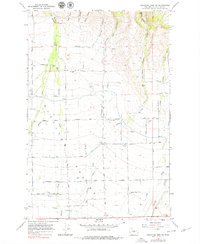
Editions of this 1966 Colockum Pass SW Map
2 editions found
Other maps of this area

1897 · Mount Stuart
USGS Topo · 1:125,000

1899 · Ellensburg
USGS Topo · 1:125,000

1901 · Ellensburg
USGS Topo · 1:125,000

1902 · Mount Stuart
USGS Topo · 1:125,000

1920 · Colockum Pass
USGS Topo · 1:125,000

1922 · Colockum Pass
USGS Topo · 1:125,000

1938 · Badger Pocket
USGS Topo · 1:48,000
1943 · Badger Pocket
USGS Topo · 1:62,500

1950 · Yakima
USGS Topo · 1:250,000
1953 · East Kittitas
USGS Topo · 1:24,000