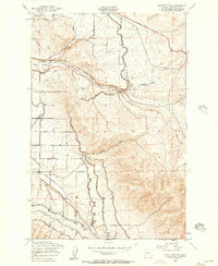
1953 Map of East Kittitas
USGS Topo · Published 1957About this map
Chicago Milwaukee St Paul and Pacific rail lines dominate the central geography of this 1950s survey, cutting through the high country as they approach the small settlement of Renslow. The landscape is a study in early mid-century water management, where complex irrigation systems including the Highline Canal and Cascade Canal snake through the foothills. This infrastructure, supported by a Pipeline, Flume, and a Pumping Sta, highlights the intensive effort required to move water from the Boylston Mountains to the lower agricultural lands near East Kittitas. In the southern portion of the quadrangle, a dense network of smaller channels like Turbine Ditch, Pump Ditch, and Gravity Ditch trace the contours of the land around Badger Creek. This map reveals the transition from the steep, dry walls of Johnson Canyon to a valley floor transformed by engineered waterways.
Find a feature on this map
21 named features on this map. Tap any name to fly to it.
Don’t see what you’re looking for? This feature index may not catch every label — zoom into the map to look around manually.
Map Details
Editions of this 1953 East Kittitas Map
2 editions found
Other maps of this area

1920 · Colockum Pass
USGS Topo · 1:125,000

1922 · Colockum Pass
USGS Topo · 1:125,000

1938 · Badger Pocket
USGS Topo · 1:48,000

1939 · Boylston
USGS Topo · 1:48,000

1943 · Boylston
USGS Topo · 1:62,500

1943 · Badger Pocket
USGS Topo · 1:62,500

1950 · Yakima
USGS Topo · 1:250,000

1953 · McDonald Spring
USGS Topo · 1:24,000
1953 · Badger Gap
USGS Topo · 1:24,000

1953 · Kittitas
USGS Topo · 1:24,000