
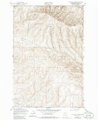
1953 Map of McDonald Spring
USGS Topo · Published 1957About this map
The Yakima Firing Center Military Reservation dominates this mid-century landscape in Kittitas County, where the southern slopes of the Saddle Mountains descend into a network of drainage basins. The map illustrates a transitional period of land use, where rugged topographical features meet military controlled territory. Key water sources like McDonald Spring and Hanson Creek are clearly marked amidst the complex elevation contours of the region.
Find a feature on this map
11 named features on this map. Tap any name to fly to it.
Don’t see what you’re looking for? This feature index may not catch every label — zoom into the map to look around manually.
Map Details
Editions of this 1953 McDonald Spring Map
2 editions found
Other maps of this area

1936 · Yakima East
USGS Topo · 1:48,000

1936 · Hog Ranch Buttes
USGS Topo · 1:48,000

1938 · Badger Pocket
USGS Topo · 1:48,000

1939 · Boylston
USGS Topo · 1:48,000

1941 · Black Rock Spring
USGS Topo · 1:62,500

1941 · Yakima East
USGS Topo · 1:62,500

1943 · Boylston
USGS Topo · 1:62,500

1943 · Badger Pocket
USGS Topo · 1:62,500

1950 · Yakima
USGS Topo · 1:250,000

1953 · Ginkgo
USGS Topo · 1:24,000