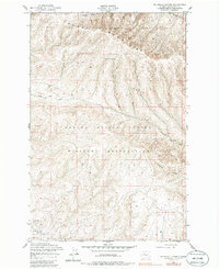
1953 Map of Mc Donald Spring
USGS Topo · Published 1985About this map
The Saddle Mountains dominate the northern landscape of this mid-century survey, creating a dramatic topographical backdrop for the Yakima Firing Center Military Reservation. The map records a transition from high ridges to the drainage systems of Squaw Creek and Cottonwood Creek in the south. Of particular interest for industrial history are the Silica Mines located in the southwestern corner, indicating the mineral extraction active in Kittitas County during this period. The terrain is defined by its water sources and rugged relief, with Mc Donald Spring providing a critical landmark in the high country. Drainage patterns like those of Hanson Creek and North Fork Squaw Creek illustrate the natural watershed of the Yakima region before later developments altered the landscape.
Find a feature on this map
9 named features on this map. Tap any name to fly to it.
Don’t see what you’re looking for? This feature index may not catch every label — zoom into the map to look around manually.
Map Details
Editions of this 1953 Mc Donald Spring Map
2 editions found
Other maps of this area

1936 · Yakima East
USGS Topo · 1:48,000

1936 · Hog Ranch Buttes
USGS Topo · 1:48,000

1938 · Badger Pocket
USGS Topo · 1:48,000

1939 · Boylston
USGS Topo · 1:48,000

1941 · Black Rock Spring
USGS Topo · 1:62,500

1941 · Yakima East
USGS Topo · 1:62,500

1943 · Boylston
USGS Topo · 1:62,500

1943 · Badger Pocket
USGS Topo · 1:62,500

1950 · Yakima
USGS Topo · 1:250,000

1953 · McDonald Spring
USGS Topo · 1:24,000