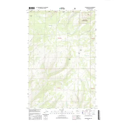
2017 Map of Colockum Pass
USGS Topo · Published 2017About this map
Colockum Pass serves as a central geographical marker within this high-elevation landscape, where the northern reaches of the Wenatchee National Forest meet the drainage basins of Kittitas County. The terrain is defined by prominent divides such as Naneum Ridge and Jumpoff Ridge, which separate a complex network of seasonal and perennial waterways. This 2017 survey details the intricate descent of several creek systems, including the Big Stemilt Cr and the branching headwaters of Tarpiscan Cr. Land use and accessibility are documented through established corridors like Coleman Creek Rd and the Ryegrass Ranches Rd, providing a clear view of the rural infrastructure and ranching tracts in the Cooke Canyon vicinity during the early twenty-first century.
Find a feature on this map
27 named features on this map. Tap any name to fly to it.
Don’t see what you’re looking for? This feature index may not catch every label — zoom into the map to look around manually.
Map Details
Editions of this 2017 Colockum Pass Map
This is the sole edition of this map. No revisions or reprints were ever made.
Other maps of this area

1912 · Malaga
USGS Topo · 1:48,000

1913 · Wenatchee
USGS Topo · 1:62,500

1914 · Malaga
USGS Topo · 1:62,500

1915 · Wenatchee
USGS Topo · 1:62,500

1920 · Colockum Pass
USGS Topo · 1:125,000

1922 · Colockum Pass
USGS Topo · 1:125,000

1957 · Wenatchee
USGS Topo · 1:250,000
1966 · Colockum Pass SW
USGS Topo · 1:24,000
1966 · Colockum Pass SE
USGS Topo · 1:24,000
1966 · Colockum Pass
USGS Topo · 1:24,000