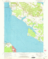
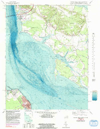
1968 Map of Colonial Beach North
USGS Topo · Published 1972About this map
The Potomac River defines the landscape of this late 1960s coastal survey, where the Maryland and Virginia border splits the wide waterway. On the northern shore in Charles County, Maryland, the terrain of Cobb Neck and Swan Point Neck is characterized by deep tidal inlets like Piccowaxen Creek and Cuckold Creek. This era shows a mix of rural Maryland life and industrial development, from the quiet presence of Old Christ Ch and the settlements of Mount Victoria and Wayside to the prominent Powerplant near the Harry W Nice Memorial Bridge. Across the water, the town of Colonial Beach serves as a Virginia riverside focal point, situated between Monroe Bay and the river's edge. Genealogists can trace family locations through numerous named burials, including Shiloh Cemetery and Good Hope Cemetery, and established landmarks like Lone Holly and Bachelors Hope Pt.
Find a feature on this map
65 named features on this map. Tap any name to fly to it.
Don’t see what you’re looking for? This feature index may not catch every label — zoom into the map to look around manually.
Map Details
Editions of this 1968 Colonial Beach North Map
5 editions found
Other maps of this area

1889 · Fredericksburg
USGS Topo · 1:125,000

1892 · Fredericksburg
USGS Topo · 1:125,000

1892 · Montross
USGS Topo · 1:62,500

1894 · Wicomico
USGS Topo · 1:62,500

1894 · Fredericksburg
USGS Topo · 1:125,000

1895 · Wicomico
USGS Topo · 1:62,500

1895 · Nomini
USGS Topo · 1:125,000

1895 · Montross
USGS Topo · 1:62,500

1898 · Nomini
USGS Topo · 1:125,000

1902 · Wicomico
USGS Topo · 1:62,500