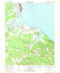
1968 Map of Colonial Beach South
USGS Topo · Published 1971About this map
George Washington Birthplace National Monument dominates the eastern shoreline of this Westmoreland County landscape, where the Potomac River meets the mouth of Popes Creek. The site features the Wakefield Mansion and Dancing Marsh, marking the ancestral grounds of the first president. To the north, the resort character of Colonial Beach is evident in the residential grid along Irving Ave and the Filtration Plant, while Monroe Hall and Monroe point to the area’s deep connections to James Monroe.
Find a feature on this map
94 named features on this map. Tap any name to fly to it.
Don’t see what you’re looking for? This feature index may not catch every label — zoom into the map to look around manually.
Map Details
Editions of this 1968 Colonial Beach South Map
4 editions found
Other maps of this area

1889 · Fredericksburg
USGS Topo · 1:125,000

1892 · Fredericksburg
USGS Topo · 1:125,000

1892 · Montross
USGS Topo · 1:62,500

1894 · Wicomico
USGS Topo · 1:62,500

1894 · Fredericksburg
USGS Topo · 1:125,000

1895 · Wicomico
USGS Topo · 1:62,500

1895 · Nomini
USGS Topo · 1:125,000

1895 · Montross
USGS Topo · 1:62,500

1898 · Nomini
USGS Topo · 1:125,000

1902 · Wicomico
USGS Topo · 1:62,500