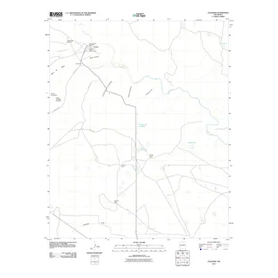
2010 Map of Colonias
USGS Topo · Published 2010About this map
The Pecos River carves through this northern New Mexico landscape, anchoring several small settlements and historic areas. In the northwest corner, the village of Colonias is surrounded by its cultural heritage, specifically the Colonias de San Jose Historic District and the La Placita de Abajo Historic District. These districts suggest a deep-rooted agricultural and communal history along the riverbank. Further downstream, smaller hamlets like El Cerrito and Casas del Medio reflect the scattered nature of habitation in the region.
Find a feature on this map
24 named features on this map. Tap any name to fly to it.
Don’t see what you’re looking for? This feature index may not catch every label — zoom into the map to look around manually.
Map Details
Editions of this 2010 Colonias Map
This is the sole edition of this map. No revisions or reprints were ever made.
Other maps of this area

1892 · Corazon
USGS Topo · 1:125,000

1894 · Corazon
USGS Topo · 1:125,000

1954 · Santa Fe
USGS Topo · 1:250,000

1954 · Fort Sumner
USGS Topo · 1:250,000

1958 · Fort Sumner
USGS Topo · 1:250,000

1958 · Santa Fe
USGS Topo · 1:250,000

1963 · Colonias
USGS Topo · 1:24,000

1963 · Santa Rosa
USGS Topo · 1:24,000

1963 · Pedro Miguel Peak
USGS Topo · 1:24,000
1963 · Horse Pasture Tank
USGS Topo · 1:24,000