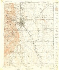
1909 Map of Colorado Springs
USGS Topo · Published 1914About this map
Colorado Springs serves as the focal point of this early 20th-century landscape, where the growing urban grid meets the dramatic rise of the Front Range. The map illustrates a period of rapid development and tourism, noting specialized institutions like the Printers Home and the historic independent municipality of Colorado City. To the west, the infrastructure of early Colorado tourism is evident, with the Manitou and Pikes Peak Ry ascending toward Pikes Peak and labels for the Grand Caverns and Cliff Dwellings marking the region's appeal as a destination.
Find a feature on this map
106 named features on this map. Tap any name to fly to it.
Don’t see what you’re looking for? This feature index may not catch every label — zoom into the map to look around manually.
Map Details
Editions of this 1909 Colorado Springs Map
5 editions found

Other maps of this area

1889 · Canon City
USGS Topo · 1:125,000

1891 · Pueblo
USGS Topo · 1:125,000

1891 · Nepesta
USGS Topo · 1:125,000

1892 · Canon City
USGS Topo · 1:125,000

1893 · Nepesta
USGS Topo · 1:125,000

1893 · Big Springs
USGS Topo · 1:125,000

1893 · Platte Canyon
USGS Topo · 1:125,000

1893 · Colorado Springs
USGS Topo · 1:125,000

1894 · Pikes Peak
USGS Topo · 1:125,000

1894 · Castle Rock
USGS Topo · 1:125,000