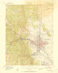
1951 Map of Colorado Springs
USGS Topo · Published 1951About this map
Colorado Springs and its surrounding communities are captured here in the early 1950s, showing a landscape defined by the transition from the Rampart Range to the plains. The map reveals the intricate development of the city's western edge, where Manitou and Colorado City are joined by the Manitou And Pikes Peak Ry and the Incline Railway climbing toward Mount Manitou. The industrial and transport footprint is substantial, with the Atchison Topeka And Santa Fe RR and the Chicago Rock Island And Pacific RR converging on the downtown core near Roswell. Beyond the urban grid, institutions such as the Modern Woodmen of America Sanitarium and the Union Printers Home emphasize the region's historical role as a center for health and recovery. Tourism and landmarks are well-represented by Garden Of The Gods, the Cave of the Winds, and the Cheyenne Mtn Zoo near the Broadmoor district.
Find a feature on this map
137 named features on this map. Tap any name to fly to it.
Don’t see what you’re looking for? This feature index may not catch every label — zoom into the map to look around manually.
Map Details
Editions of this 1951 Colorado Springs Map
2 editions found
Other maps of this area

1893 · Platte Canyon
USGS Topo · 1:125,000

1893 · Colorado Springs
USGS Topo · 1:125,000

1894 · Pikes Peak
USGS Topo · 1:125,000

1894 · Castle Rock
USGS Topo · 1:125,000

1901 · Pikes Peak
USGS Topo · 1:125,000

1901 · Pikes Peak
USGS Topo · 1:62,500

1909 · Colorado Springs
USGS Topo · 1:125,000

1913 · Castle Rock
USGS Topo · 1:125,000

1940 · Elbert
USGS Topo · 1:62,500

1942 · Colorado Springs
USGS Topo · 1:125,000