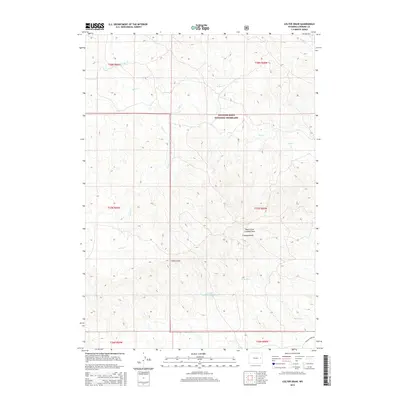
2015 Map of Colter Draw
USGS Topo · Published 2015About this map
Thunder Basin National Grassland dominates this high plains landscape in Converse County, where the intricate drainage patterns of the Powder River Basin are clearly defined. The terrain is characterized by numerous ephemeral watercourses and draws, including the primary namesake Colter Draw, alongside the North Fork Crooked Draw and Crooked Draw. These geographical features demonstrate the erosional forces typical of the Wyoming steppe, carving deep into the plateau. Human impact on the land is represented by the Coulter Number 1 Reservoir, a vital water management site in this arid environment. Significant water bodies such as Horse Cr, Willow Cr, and Rat Cr cross the townships, while Walker Creek Rd provides a primary point of access in the southeastern corner of the quadrangle.
Find a feature on this map
19 named features on this map. Tap any name to fly to it.
Don’t see what you’re looking for? This feature index may not catch every label — zoom into the map to look around manually.
Map Details
Editions of this 2015 Colter Draw Map
This is the sole edition of this map. No revisions or reprints were ever made.
Other maps of this area

1955 · Newcastle
USGS Topo · 1:250,000

1958 · Newcastle
USGS Topo · 1:250,000

1970 · Bill 4 SE
USGS Topo · 1:24,000

1970 · Bill 4 NW
USGS Topo · 1:24,000
1970 · Bill 4 SW
USGS Topo · 1:24,000

1970 · Bill 4 NE
USGS Topo · 1:24,000

1971 · Esau Spring
USGS Topo · 1:24,000

1971 · Tin Can Lake
USGS Topo · 1:24,000

1979 · Bill
USGS Topo · 1:100,000

1981 · Pinnacle Rocks
USGS Topo · 1:24,000