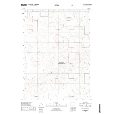
2017 Map of Colter Draw
USGS Topo · Published 2017About this map
Thunder Basin National Grassland dominates this high plains landscape in Converse County, where a complex network of ephemeral drainages defines the geography. The terrain is characterized by deep erosional features like Colter Draw and the North Fork Crooked Draw, which illustrate the region's long-term hydrological patterns. In this part of eastern Wyoming, the drainage systems of Horse Cr and Bobcat Cr weave through sections of public and private land, reflecting the ranching and grazing heritage of the area. The map shows the intersection of several townships, including t37n r69w and t38n r68w, providing a detailed view of the Public Land Survey System. While mostly devoid of permanent settlements, the presence of Co RD 43 in the southeastern corner indicates the minimal but essential transportation network serving this expansive grassland environment.
Find a feature on this map
19 named features on this map. Tap any name to fly to it.
Don’t see what you’re looking for? This feature index may not catch every label — zoom into the map to look around manually.
Map Details
Editions of this 2017 Colter Draw Map
This is the sole edition of this map. No revisions or reprints were ever made.
Other maps of this area

1955 · Newcastle
USGS Topo · 1:250,000

1958 · Newcastle
USGS Topo · 1:250,000

1970 · Bill 4 SE
USGS Topo · 1:24,000

1970 · Bill 4 NW
USGS Topo · 1:24,000
1970 · Bill 4 SW
USGS Topo · 1:24,000

1970 · Bill 4 NE
USGS Topo · 1:24,000

1971 · Esau Spring
USGS Topo · 1:24,000

1971 · Tin Can Lake
USGS Topo · 1:24,000

1979 · Bill
USGS Topo · 1:100,000

1981 · Pinnacle Rocks
USGS Topo · 1:24,000