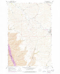
1964 Map of Colton
USGS Topo · Published 1977About this map
Colton serves as the primary hub in this corner of Whitman County, shown during a period of transition in the mid-1970s. The town site is clearly defined by its High Sch, local Cem, and the vital Burlington Northern railroad line that skirts the eastern edge of the community. Beyond the settled area, the landscape is deeply incised by a series of dramatic coulees and canyons, most notably Yakawawa Canyon, Nisqually John Canyon, and Steptoe Canyon, which all drain toward the river system to the southwest. The southwestern corner of the sheet reveals a significant aquatic landscape where the Lower Snake River forms Lake Granite, marking the border with Garfield County. Remote outposts like the Nesterbank Ranch highlight the specialized agricultural and ranching operations that have long utilized the complex topography between the high flats and the river breaks.
Find a feature on this map
20 named features on this map. Tap any name to fly to it.
Don’t see what you’re looking for? This feature index may not catch every label — zoom into the map to look around manually.
Map Details
Editions of this 1964 Colton Map
2 editions found
Other maps of this area

1910 · Pullman
USGS Topo · 1:125,000

1943 · Peola
USGS Topo · 1:62,500

1945 · Clarkston
USGS Topo · 1:62,500

1946 · Peola
USGS Topo · 1:62,500

1948 · Clarkston
USGS Topo · 1:62,500

1955 · Pullman
USGS Topo · 1:250,000

1958 · Pullman
USGS Topo · 1:250,000

1964 · Moscow West
USGS Topo · 1:24,000

1964 · Colton
USGS Topo · 1:24,000

1964 · Ewartsville
USGS Topo · 1:24,000