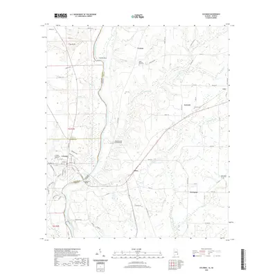
2020 Map of Columbia
USGS Topo · Published 2020About this map
The Chattahoochee River forms a wide, meandering boundary between Alabama and Georgia, defining the eastern edge of this region. Near the riverbanks, the town of Columbia serves as a primary hub, with local roads like Stillwater Rd and Lizard Lope Rd radiating into the surrounding countryside. The landscape is dotted with small settlements such as Hilton, Sawhatchee, and Freeman, each connected by a network of rural routes that follow the winding paths of Coheelee Cr and Sawhatchee Cr.
Find a feature on this map
77 named features on this map. Tap any name to fly to it.
Don’t see what you’re looking for? This feature index may not catch every label — zoom into the map to look around manually.
Map Details
Editions of this 2020 Columbia Map
This is the sole edition of this map. No revisions or reprints were ever made.
Other maps of this area

1953 · Dothan
USGS Topo · 1:250,000

1954 · Dothan
USGS Topo · 1:250,000

1955 · Dothan
USGS Topo · 1:250,000

1970 · Gordon
USGS Topo · 1:24,000

1970 · Columbia NE
USGS Topo · 1:24,000

1970 · Haleburg
USGS Topo · 1:24,000

1970 · Sigma
USGS Topo · 1:24,000

1970 · Columbia
USGS Topo · 1:24,000
1970 · Ashford
USGS Topo · 1:24,000

1973 · Blakely North
USGS Topo · 1:24,000