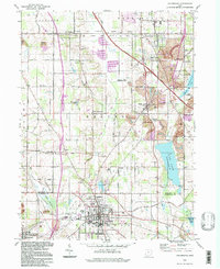
1994 Map of Columbiana
USGS Topo · Published 1997About this map
Columbiana sits at the heart of this landscape, where the street grid gives way to Firestone Park and the winding course of Mill Creek. This 1990s record captures the region's complex history of land use, from the residential clusters at North Lima and Woodworth to the extensive areas of reclaimed Strip Mine operations. The boundary between the Connecticut Western Reserve and the Congress Lands North of the Old Seven Ranges creates a distinct shift in the rural road network, dividing the northern township of Boardman from the southern reaches of Fairfield.
Find a feature on this map
57 named features on this map. Tap any name to fly to it.
Don’t see what you’re looking for? This feature index may not catch every label — zoom into the map to look around manually.
Map Details
Editions of this 1994 Columbiana Map
This is the sole edition of this map. No revisions or reprints were ever made.
Other maps of this area

1906 · Youngstown
USGS Topo · 1:62,500

1907 · Columbiana
USGS Topo · 1:62,500

1908 · Youngstown
USGS Topo · 1:62,500

1908 · Warren
USGS Topo · 1:62,500

1909 · Lisbon
USGS Topo · 1:62,500

1909 · Columbiana
USGS Topo · 1:62,500

1950 · Cleveland
USGS Topo · 1:250,000

1951 · Canton
USGS Topo · 1:250,000

1951 · Columbiana
USGS Topo · 1:24,000

1951 · Campbell
USGS Topo · 1:24,000