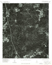
1975 Map of Columbiana SW
USGS Topo · Published 1977About this map
Dense woodland and timbering patterns define the mid-1970s landscape of north-central Alabama. This orthophotoquad, produced through optical scanning of aerial imagery, offers a rare textural view of the terrain rather than a conventional line-drawn survey. The winding path of Bumpratchet cuts through the ridges, serving as a primary drainage for the area's complex topography. Because this is a photographic study, it reveals the specific clearing patterns and access roads of the era, illustrating how the rural landscape was managed by local landholders and the Soil Conservation Service during a period of transition in land use.
Find a feature on this map
1 named feature on this map. Tap any name to fly to it.
Don’t see what you’re looking for? This feature index may not catch every label — zoom into the map to look around manually.
Map Details
Editions of this 1975 Columbiana SW Map
This is the sole edition of this map. No revisions or reprints were ever made.
Other maps of this area

1890 · Bessemer
USGS Topo · 1:125,000

1891 · Clanton
USGS Topo · 1:125,000

1892 · Bessemer
USGS Topo · 1:125,000

1909 · Columbiana
USGS Topo · 1:62,500

1910 · Montevallo
USGS Topo · 1:62,500

1911 · Columbiana
USGS Topo · 1:62,500

1953 · Montgomery
USGS Topo · 1:250,000

1953 · Birmingham
USGS Topo · 1:250,000

1956 · Birmingham
USGS Topo · 1:250,000

1956 · Montgomery
USGS Topo · 1:250,000