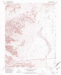
1967 Map of Columbus
USGS Topo · Published 1982About this map
The Columbus Salt Marsh (Alkali Flat) dominates the eastern basin of this high-desert landscape at the foot of the Candelaria Hills. During the late 1960s, this area of the Nevada desert remained largely defined by its natural drainage patterns and mineral potential, with the settlement of Columbus situated on the edge of the expansive salt flats. The topography reveals a dramatic transition from the alluvial fans of Pinchot Creek to the rugged elevations of the Volcanic Hills in the south.
Find a feature on this map
14 named features on this map. Tap any name to fly to it.
Don’t see what you’re looking for? This feature index may not catch every label — zoom into the map to look around manually.
Map Details
Editions of this 1967 Columbus Map
3 editions found
Other maps of this area

1898 · Silver Peak
USGS Topo · 1:125,000

1900 · Silver Peak
USGS Topo · 1:125,000

1907 · Tonopah
USGS Topo · 1:250,000

1908 · Lida
USGS Topo · 1:250,000

1908 · Tonopah
USGS Topo · 1:250,000

1909 · Hawthorne
USGS Topo · 1:250,000

1911 · Hawthorne
USGS Topo · 1:250,000

1913 · Lida
USGS Topo · 1:250,000

1915 · Hawthorne
USGS Topo · 1:250,000

1917 · White Mountain
USGS Topo · 1:125,000