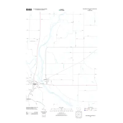
2013 Map of Columbus Junction
USGS Topo · Published 2013About this map
The confluence of the Iowa River and Cedar River dominates this landscape, where the waters meet just east of Columbus Junction. This 2013 survey illustrates a region defined by its river-bottom geography and the established communities of Columbus City and Fredonia. The topography reveals a complex network of agricultural drainage, including the prominent Ditch Number 25, and local water bodies like Cone Lake. Evidence of civic and recreational life is centered near the river fork, notably at the Louisa County Fair Grounds and the River Fork Boat Ramp. Further north, the small settlement of Alimeda sits along the Muscatine-Louisa Co Line, while numerous creeks such as Pike Cr, Indian Cr, and Johnny Cr weave through the surrounding farmland. The map provides a contemporary view of these river towns as they integrate modern infrastructure with their traditional floodplain locations.
Find a feature on this map
65 named features on this map. Tap any name to fly to it.
Don’t see what you’re looking for? This feature index may not catch every label — zoom into the map to look around manually.
Map Details
Editions of this 2013 Columbus Junction Map
This is the sole edition of this map. No revisions or reprints were ever made.
Other maps of this area

1946 · Wapello
USGS Topo · 1:62,500

1948 · Muscatine
USGS Topo · 1:62,500

1949 · Wapello
USGS Topo · 1:62,500

1958 · Davenport
USGS Topo · 1:250,000

1961 · Davenport
USGS Topo · 1:250,000

1962 · Davenport
USGS Topo · 1:250,000

1965 · Letts
USGS Topo · 1:24,000
1965 · Muscatine NW
USGS Topo · 1:24,000
1965 · Wapello
USGS Topo · 1:24,000
1969 · Lone Tree
USGS Topo · 1:24,000