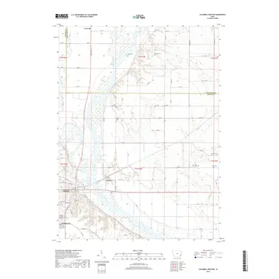
2018 Map of Columbus Junction
USGS Topo · Published 2018About this map
The confluence of the Iowa River and Cedar River dominates this portion of Louisa County, creating a landscape defined by broad river bottoms and the communities that grew alongside them. Columbus Junction sits as the primary hub at the southern edge of the sheet, situated near the western bank of the Iowa River where it merges with the Cedar. To the south, Columbus City maintains its own distinct footprint, while the smaller settlement of Fredonia occupies the narrow strip of land between the two rivers just north of their junction.
Find a feature on this map
63 named features on this map. Tap any name to fly to it.
Don’t see what you’re looking for? This feature index may not catch every label — zoom into the map to look around manually.
Map Details
Editions of this 2018 Columbus Junction Map
This is the sole edition of this map. No revisions or reprints were ever made.
Other maps of this area

1946 · Wapello
USGS Topo · 1:62,500

1948 · Muscatine
USGS Topo · 1:62,500

1949 · Wapello
USGS Topo · 1:62,500

1958 · Davenport
USGS Topo · 1:250,000

1961 · Davenport
USGS Topo · 1:250,000

1962 · Davenport
USGS Topo · 1:250,000

1965 · Letts
USGS Topo · 1:24,000
1965 · Muscatine NW
USGS Topo · 1:24,000
1965 · Wapello
USGS Topo · 1:24,000
1969 · Lone Tree
USGS Topo · 1:24,000