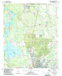
1987 Map of Columbus North
USGS Topo · Published 1987About this map
Columbus Air Force Base dominates the northern landscape of this Lowndes County map, illustrating the heavy military and aviation presence in the region during the late 1980s. Southward, the city of Columbus shows its developed grid, where institutional landmarks like Lee High Sch, Hunt High Sch, and the Regional Medical Center anchor the community. The water systems define the western edge, particularly the complex engineering of the Tennessee-Tombigbee Waterway, which includes the Waverly Mansion Cut-Off and the Columbus Lock and Dam. This period reflects a landscape shaped by significant mid-century hydrological changes alongside established local centers of worship such as Calvary Ch and Hopewell Ch. For genealogists and local historians, the map documents a transition from rural clusters like Baldwin to the expanded infrastructure of the modern city, including the Southern Railway corridor and the winding course of Luxapallila Creek.
Find a feature on this map
97 named features on this map. Tap any name to fly to it.
Don’t see what you’re looking for? This feature index may not catch every label — zoom into the map to look around manually.
Map Details
Editions of this 1987 Columbus North Map
2 editions found
Other maps of this area

1953 · West Point
USGS Topo · 1:250,000

1958 · West Point
USGS Topo · 1:250,000

1959 · Artesia
USGS Topo · 1:62,500

1959 · West Point
USGS Topo · 1:62,500

1960 · Caledonia
USGS Topo · 1:62,500

1960 · Columbus
USGS Topo · 1:62,500

1963 · West Point
USGS Topo · 1:250,000

1982 · West Point
USGS Topo · 1:100,000

1984 · West Point
USGS Topo · 1:250,000
1987 · Hamilton
USGS Topo · 1:24,000