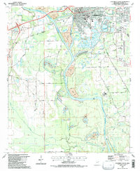
1987 Map of Columbus South
USGS Topo · Published 1987About this map
The Tennessee Tombigbee Waterway dominates the landscape south of Columbus, where heavy infrastructure and local history intersect along the river's path. In the late 1980s, the area reflects a transition from traditional rural settlements to industrial utility, evidenced by extensive Gravel Pits and various disposal areas alongside the Gulf and Mississippi and Frisco Northern rail lines. Historically significant sites like Friendship Cem and Sandfield Cem are documented alongside the community at Yorkville. The map captures a high degree of local detail for genealogists, including numerous rural churches such as Brick Ch and Clairborne Ch, and educational landmarks like the West Lowndes Sch. The confluence of Luxapallila Creek and the river provides a natural boundary for the Luxapallila Creek Recreation Area, balancing the industrial activity of the Columbus-Lowndes County Airport.
Find a feature on this map
74 named features on this map. Tap any name to fly to it.
Don’t see what you’re looking for? This feature index may not catch every label — zoom into the map to look around manually.
Map Details
Editions of this 1987 Columbus South Map
2 editions found
Other maps of this area

1953 · West Point
USGS Topo · 1:250,000

1958 · West Point
USGS Topo · 1:250,000

1959 · Artesia
USGS Topo · 1:62,500

1959 · West Point
USGS Topo · 1:62,500

1960 · Caledonia
USGS Topo · 1:62,500

1960 · Columbus
USGS Topo · 1:62,500

1963 · West Point
USGS Topo · 1:250,000

1982 · West Point
USGS Topo · 1:100,000

1984 · West Point
USGS Topo · 1:250,000
1987 · Columbus North
USGS Topo · 1:24,000