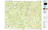
1984 Map of Colville
USGS Topo · Published 1984About this map
Colville serves as the primary hub in this 1984 survey of the northeastern corner of Washington, where the Colville National Forest and Kaniksu National Forest dominate the high-altitude landscape. The map captures a region defined by its rugged mineral wealth and water power, with the Columbia River and Lake Roosevelt forming the western boundary while the Pend Oreille River carves through the eastern reaches. The density of mining operations is a standout feature, documenting dozens of sites such as the Van Stone Mine, Copper King Mine, and Lead Pencil Mine. Transportation corridors like the Burlington Northern railroad and U.S. Highway 395 connect small settlements like Northport and Metaline Falls. This edition also details protected lands, including the Little Pend Oreille National Wildlife Refuge and Crawford State Park near the Canadian border.
Find a feature on this map
212 named features on this map. Tap any name to fly to it.
Don’t see what you’re looking for? This feature index may not catch every label — zoom into the map to look around manually.
Map Details
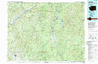
Editions of this 1984 Colville Map
2 editions found
Other maps of this area

1901 · Sandpoint
USGS Topo · 1:125,000

1911 · Priest Lake
USGS Topo · 1:250,000

1911 · Sandpoint
USGS Topo · 1:125,000

1913 · Priest Lake
USGS Topo · 1:250,000

1927 · Chewelah
USGS Topo · 1:125,000

1929 · Colville
USGS Topo · 1:125,000

1930 · Chewelah
USGS Topo · 1:125,000

1933 · Colville
USGS Topo · 1:125,000

1934 · Metaline
USGS Topo · 1:125,000

1936 · Marcus
USGS Topo · 1:96,000