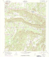
1957 Map of Colvin Gap
USGS Topo · Published 1984About this map
Colvin Mountain and Dry Creek Mountain dominate the center of this landscape, creating a distinct topographical barrier between the Etowah Co Calhoun Co line. The settlement patterns follow the base of these ridges, with Hokes Bluff appearing in the northwest and Ohatchee in the southwest. A significant density of rural institutions is mapped throughout these valleys, including numerous family-named landmarks like Youngs Chapel, Webster Chapel, and Landers Cem.
Find a feature on this map
30 named features on this map. Tap any name to fly to it.
Don’t see what you’re looking for? This feature index may not catch every label — zoom into the map to look around manually.
Map Details
Editions of this 1957 Colvin Gap Map
3 editions found
Other maps of this area

1893 · Fort Payne
USGS Topo · 1:125,000

1898 · Fort Payne
USGS Topo · 1:125,000

1900 · Fort Payne
USGS Topo · 1:125,000

1900 · Anniston
USGS Topo · 1:125,000

1947 · Colvin Gap
USGS Topo · 1:24,000

1947 · Jacksonville
USGS Topo · 1:24,000

1947 · Glencoe
USGS Topo · 1:24,000

1947 · Wellington
USGS Topo · 1:24,000

1947 · Jacksonville
USGS Topo · 1:62,500

1953 · Atlanta
USGS Topo · 1:250,000