
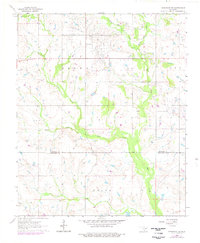
1964 Map of Comanche SE
USGS Topo · Published 1965About this map
The rolling plains of southern Oklahoma meet the industrial footprint of the mid-century energy boom in this survey from the early 1960s. Straddling the boundary between Stephens Co and Jefferson Co, the landscape is defined by the winding paths of Mud Creek and its tributaries, including West Mud Creek and East Mud Creek. The presence of a significant Oil Field in the northeast corner of the sheet reflects the region's reliance on petroleum extraction during this era, with numerous drilling sites and service roads crisscrossing the terrain. Settlement patterns are focused around rural communities such as Brown, Price, and Loco. For those researching family history in the area, Woolsey Cem provides a specific point of interest, while the drainage of Deer Creek and the South Fork Deer Creek offers a look at the local topography before modern land-use changes.
Find a feature on this map
11 named features on this map. Tap any name to fly to it.
Don’t see what you’re looking for? This feature index may not catch every label — zoom into the map to look around manually.
Map Details
Editions of this 1964 Comanche SE Map
2 editions found
Other maps of this area

1901 · Addington
USGS Topo · 1:125,000

1957 · Ardmore
USGS Topo · 1:250,000

1962 · Ryan
USGS Topo · 1:62,500

1963 · Ardmore
USGS Topo · 1:250,000

1963 · Harrisburg
USGS Topo · 1:24,000

1964 · Duncan South
USGS Topo · 1:24,000

1964 · Comanche
USGS Topo · 1:24,000

1974 · Ringling NW
USGS Topo · 1:24,000

1974 · Loco
USGS Topo · 1:24,000
1974 · Velma
USGS Topo · 1:24,000