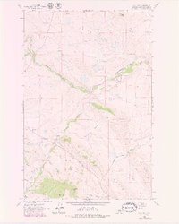
1961 Map of Comb Rock
USGS Topo · Published 1979About this map
The Dearborn River winds through this Montana landscape, where cattle ranching and early community infrastructure define the mountain valleys. Established ranch sites such as the Ostle Ranch and Burggraff Ranch occupy the lowlands near the water, while the Dearborn Cem and South Fork Sch reflect the social foundations of the local residents. The terrain transitions from the river valley to prominent geological formations, including the massive uplift of The Reef and the distinct peak of Limekiln Mountain. The network of seasonal drainages, including Auchard Creek and Jeffries Creek, illustrates the complex hydrology that supported these high-country operations. Tracing the Stearns-Wolf Creek Road, one can see how early transportation routes followed the natural contours of Nicholas Basin to connect isolated homesteads like the Murphy Ranch.
Find a feature on this map
30 named features on this map. Tap any name to fly to it.
Don’t see what you’re looking for? This feature index may not catch every label — zoom into the map to look around manually.
Map Details
Editions of this 1961 Comb Rock Map
3 editions found
Other maps of this area

1943 · Hogan
USGS Topo · 1:125,000

1955 · Choteau
USGS Topo · 1:250,000

1957 · Choteau
USGS Topo · 1:250,000

1958 · Choteau
USGS Topo · 1:250,000
1961 · Roberts Mountain
USGS Topo · 1:24,000
1961 · Wolf Creek
USGS Topo · 1:24,000
1961 · Coburn Mountain
USGS Topo · 1:24,000
1961 · Comb Rock
USGS Topo · 1:24,000

1962 · Choteau
USGS Topo · 1:250,000
1962 · Bowmans Corners
USGS Topo · 1:24,000