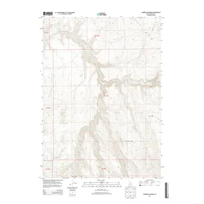
2013 Map of Combination Ridge
USGS Topo · Published 2013About this map
Combination Ridge and Rose Ridge dominate the landscape of Owyhee County in this 2013 U.S. Geological Survey study, revealing a complex network of high-desert drainage systems. The topography is defined by the deep incisions of Big Boulder Creek and its various tributaries, including N Boulder Cr and S Boulder Cr. These waterways carve through the high elevations, creating a corrugated terrain that dictated the placement of early routes. Two primary corridors, Flint Rd and S Mountain Rd, traverse the high ground, connecting remote parts of the county. The map detail highlights the numerous seasonal and perennial streams like Old Man Cr and Combination Cr that flow away from the central heights toward the Vulcan Gulch area. This survey provides a precise look at the land management boundaries of Townships 6, 7, and 8 South, showing how the natural geography of S Mountain Cr and surrounding peaks intersects with the Public Land Survey System grid.
Find a feature on this map
24 named features on this map. Tap any name to fly to it.
Don’t see what you’re looking for? This feature index may not catch every label — zoom into the map to look around manually.
Map Details
Editions of this 2013 Combination Ridge Map
This is the sole edition of this map. No revisions or reprints were ever made.
Other maps of this area

1955 · Jordan Valley
USGS Topo · 1:250,000

1957 · Jordan Valley
USGS Topo · 1:250,000

1958 · Jordan Valley
USGS Topo · 1:250,000

1965 · Triangle
USGS Topo · 1:62,500

1965 · Flint Creek
USGS Topo · 1:62,500

1973 · Indian Meadows
USGS Topo · 1:24,000

1973 · Wickiup Creek
USGS Topo · 1:24,000

1973 · Cliffs
USGS Topo · 1:24,000
1990 · Triangle
USGS Topo · 1:100,000
1990 · Triangle Flat
USGS Topo · 1:24,000