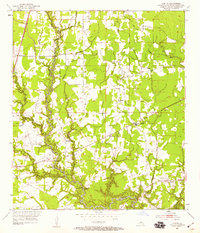
1953 Map of Comite
USGS Topo · Published 1959About this map
The Comite River and its dense network of tributaries, including Blackwater Bayou and Beaver Bayou, define the landscape of East Baton Rouge Parish during the early 1950s. This survey illustrates a rural-to-suburban transition, where established family landmarks and small communities like Puckett and Comite are connected by a growing web of roads. The distribution of spiritual and educational centers, such as Shady Grove Ch, Zoar Ch, and Central High Sch, points to a well-integrated social fabric in the countryside north of Baton Rouge.
Find a feature on this map
18 named features on this map. Tap any name to fly to it.
Don’t see what you’re looking for? This feature index may not catch every label — zoom into the map to look around manually.
Map Details
Editions of this 1953 Comite Map
2 editions found

Other maps of this area

1906 · Bayou Sara
USGS Topo · 1:125,000

1908 · Baton Rouge
USGS Topo · 1:62,500

1934 · Denham Springs
USGS Topo · 1:62,500

1939 · Zachary
USGS Topo · 1:62,500

1939 · Denham Springs
USGS Topo · 1:62,500

1939 · Baton Rouge
USGS Topo · 1:62,500

1942 · Pride
USGS Topo · 1:31,680

1942 · Watson
USGS Topo · 1:31,680

1953 · Baton Rouge West
USGS Topo · 1:24,000
1953 · Baton Rouge East
USGS Topo · 1:24,000