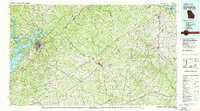
1979 Map of Commerce
USGS Topo · Published 1980About this map
The Lake Sidney Lanier shoreline and the upper reaches of Hartwell Lake anchor this 1970s landscape, reflecting the significant water management projects that transformed Northeast Georgia. Between these major reservoirs, the regional transportation network is defined by the Southern and Seaboard Coast Line railroads, which connect agricultural centers like Commerce and Jefferson to the growing hub of Gainesville. The presence of Gainesville Memorial Airport and Jackson County Airport highlights the area's increasing accessibility during this period.
Find a feature on this map
85 named features on this map. Tap any name to fly to it.
Don’t see what you’re looking for? This feature index may not catch every label — zoom into the map to look around manually.
Map Details
Editions of this 1979 Commerce Map
2 editions found
Other maps of this area

1886 · Dahlonega
USGS Topo · 1:125,000

1886 · Walhalla
USGS Topo · 1:125,000

1888 · Ellijay
USGS Topo · 1:125,000

1888 · Pickens
USGS Topo · 1:125,000

1888 · Atlanta
USGS Topo · 1:125,000

1890 · Suwanee
USGS Topo · 1:125,000

1890 · Atlanta
USGS Topo · 1:125,000

1891 · Gainesville
USGS Topo · 1:125,000

1891 · Carnesville
USGS Topo · 1:125,000

1892 · Dahlonega
USGS Topo · 1:125,000