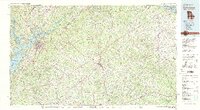
1979 Map of Commerce
USGS Topo · Published 1980About this map
The upper Piedmont region of Georgia and South Carolina transitions from the rising foothills of the Chattahoochee National Forest to the sprawling waters of Lake Sidney Lanier and Hartwell Lake. Compiled from surveys through 1972, this map records the transportation backbone of the era, defined by the Southern and Seaboard Coast Line railroads and the corridor of I-85. Local centers like Gainesville, Commerce, and Jefferson anchor a landscape still deeply rooted in rural community life, marked by landmarks such as the Maysville Sch and Clemons Chapel.
Find a feature on this map
140 named features on this map. Tap any name to fly to it.
Don’t see what you’re looking for? This feature index may not catch every label — zoom into the map to look around manually.
Map Details
Editions of this 1979 Commerce Map
2 editions found
Other maps of this area

1886 · Dahlonega
USGS Topo · 1:125,000

1886 · Walhalla
USGS Topo · 1:125,000

1888 · Ellijay
USGS Topo · 1:125,000

1888 · Pickens
USGS Topo · 1:125,000

1888 · Atlanta
USGS Topo · 1:125,000

1890 · Suwanee
USGS Topo · 1:125,000

1890 · Atlanta
USGS Topo · 1:125,000

1891 · Gainesville
USGS Topo · 1:125,000

1891 · Carnesville
USGS Topo · 1:125,000

1892 · Dahlonega
USGS Topo · 1:125,000