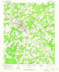
1964 Map of Commerce
USGS Topo · Published 1965About this map
Commerce serves as the central hub of this 1960s landscape, where the Southern railroad line bisects the town, anchoring a network of schools, waterworks, and the Banks-Jackson-Commerce Hospital. Outside the town center, the area is defined by its rural institutions and community landmarks, such as the Bolton Airport and the Drive-in Theater south of town. The map reveals a high density of family-named cemeteries and country churches, including the Harris-Lord Cem, Gray Hill Cem, and Cabin Creek Ch, which provide valuable location data for genealogists.
Find a feature on this map
37 named features on this map. Tap any name to fly to it.
Don’t see what you’re looking for? This feature index may not catch every label — zoom into the map to look around manually.
Map Details
Editions of this 1964 Commerce Map
2 editions found
Other maps of this area

1891 · Gainesville
USGS Topo · 1:125,000

1891 · Carnesville
USGS Topo · 1:125,000

1954 · Greenville
USGS Topo · 1:250,000

1958 · Greenville
USGS Topo · 1:250,000

1964 · Commerce
USGS Topo · 1:24,000

1964 · Maysville
USGS Topo · 1:24,000

1964 · Ila
USGS Topo · 1:24,000

1964 · Ashland
USGS Topo · 1:24,000
1964 · Nicholson
USGS Topo · 1:24,000

1964 · Hull
USGS Topo · 1:24,000